The last time I blogged about satellites, it was related to Amateur (ham radio) satellites. Yesterday I read a news story about a company called World Space that had just raised a lot of money for a broadcast radio satellite system in Europe, Africa, and Asia similar to those used by XM and Sirius in North America. The man behind World Space is Noah Samara and he is a key figure in satellite radio development. I looked him up on Google and found that he had graduated from East Stroudsburg State College in Pennsylvania. I know this because he was asked to come back and give a commencement speech and I must say that it’s one of the best commencement speeches I’ve read.
I’ve always been intrigued by these new radio broadcast satellites, since I know the challenges and limitations of satellite communications and I’m pretty sure I would have been one of the people who would have questioned the technical and logistical feasibility of such a business model had I been asked for my opinion, say around 1990, when Noah started his company. And it sounds like I wouldn’t have been alone. It’s a good thing that people persevere in spite of the experts’ opinions.
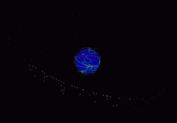
I’ve been toying with the idea of getting a satellite radio, one that I could move between my car, motorcycle, and airplane and so I wanted to figure out the difference between the two approaches used by Sirius and XM. In the case of XM, they use standard geo-synchronous satellites which are located in the Clark belt, which is a ring aligned with the equator about 24,000 miles from the earth. Most communication satellites are in this location because it allows them to be weightless as they rotate with the earth. Their centripetal force exactly cancels out the gravitational pull of the earth. Therefore, they need to use little fuel to stay positioned. It’s a good thing too, since a satellite’s life expectancy is around 15 years and there are no refueling stations in the Clark belt. This also gives them the advantage of staying in one location, so high gain dish antennas can be used which means they don’t have to transmit their signal with as much power (power is also a scarce resource in space). However, that advantage is lost with satellite radio because in a mobile environment, you can’t expect to keep a highly directional dish antenna pointed at the satellite.
If you click on the image above, you’ll get a larger image which makes it easier to see all of the man-made satellites orbiting the earth in the Clark belt. If you look closer to the globe, you can see the low-earth orbiting satellites, which orbit the earth approximately every 100 minutes, flying just a few hundred miles above the surface. These are satellites used to take images such as the spy satellites and weather satellites. If you would like to see where these images came from, visit the J-Track website sponsored by NASA and select Jtrack 3D. It requires a Java applet to be downloaded to your computer, but the results are definitely worth it. You can rotate the whole image around and view these satellites from every angle.
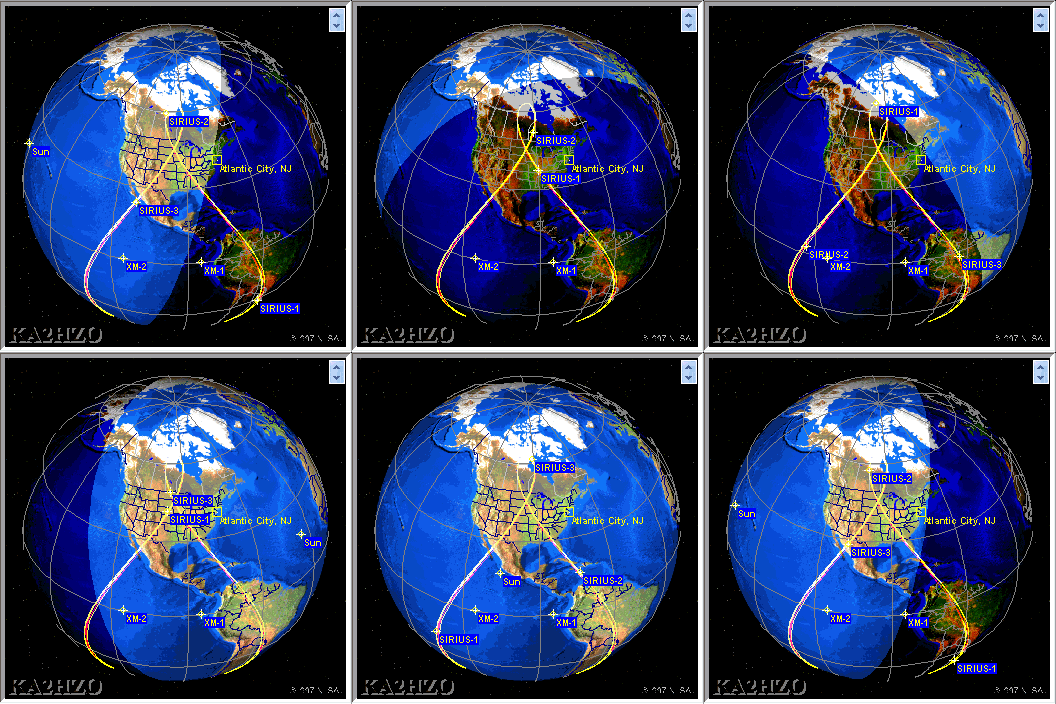
Sirius uses a completely different approach. They use an elliptical orbit that allows the 3 satellites to spend more time directly overhead since in North America geosynchronous satellites have a low angle and can be more easily blocked by buildings, or even a passing truck.
You can see from the animation above that there is always at least one satellite over the U.S. at all times. The orbit for each satellite takes about a day.
Both companies use ground-based repeaters to help overcome the inevitable dead spots created by obstructions, but this only needs to be done in a relatively small number of urban locations. Sirius, because of the less obstructed view of the satellites needs fewer repeaters.
If you are interested in comparing the two satellite radio companies to see the features of their respective products, there is a nice chart of it here.


Mr. Devlin,
i enjoyed your brief regarding the Sirius satellites orbits. i found it when trying to answer a little different question I had. i became familiar with the Sirius orbits when i downloaded a satellite tracking program to go with a star tracking program for my Android or iPad. For a moment I thought you may address my question, but unfortunately you did not.
My question: how is this orbit maintained? You touched on it in you analysis of tne Clark’s belt – fuel. i cannot imagine these satellites carry enough fuel to make several “burns” daily, but how else are they able to change direction on a daily basis? Surely not neuclear energy, or couldnit be? this would seem to be a radical & cost prohibitive alternative for a company like Siriius, still in an enfant stage. Will an orbit of this shape maintain itself with gravitational or physical forces?
i look forward to future reading if paths cross. maybe it’s in the stars…..
Addison Davis
Albany, Ga USA
Hi Addison, Excellent question. The Sirius satellites are in a high elliptical orbit, called a Molniya orbit. You can read more about it here. The animated picture in the posting may be a bit misleading because you can’t tell that the figure 8 motion that you see over North America is caused by a combination of the satellite’s motion along with the rotation of the earth. As the satellite comes back down from its high orbit, it gets closer to the earth and then gets slung back up into space at a very high altitude which makes it look like it’s stationary as it reaches its apogee. That’s why the figure 8 is not symmetrical, one portion is made while the satellite is close to the earth and the other portion is made when it’s back up at maximum altitude. The earth is not at the center of its orbit, instead it is at one of the foci of the elliptical path.
There are several types of satellite orbits, for example, a low earth orbit which is just a few hundred miles up, usually circling from North to South. These satellites include some of the spy satellites and ham radio satellites. They travel at about 17,000 mph and make an orbit every 90 minutes. The GPS constellation is up around 12,000 miles above the earth and constantly moving in precise circular orbits and need minor amounts of fuel to keep themselves exactly where they are supposed to be. But needing to use fuel constantly wouldn’t work on a satellite, because it would severely limit the life of it, so they depend on the satellite’s speed and the earth’s gravity and the vacuum of space stay in the orbit with minimal need to add energy. The design life of the GPS satellites is finite, and was estimated to be around 8-10 years. Many have lasted much longer than that. All will fail eventually, and the Air Force has to keep sending up new ones to replace them. They have launched 59 GPS satellites to date of which 31 are still functional. They need to keep at least 24 functional to avoid having outages in GPS coverage. Sorry for that tangent ;-).